At the Beginnings of the Statehood in Eastern Georgia (on the Example of the Land between the rivers Iori and Alazani)
DOI: 10.55804/jtsuSPEKALI-18-4
Geographically, the South Caucasus is an integral part of the Near East. Their past should not be considered separately.
This fact was once again confirmed by the archaeological finds in eastern Georgia, namely, in the eastern part of the plateau located between the rivers Alazani and Iori. These finds date back to the end of the 2nd -1st millennia BC. Geographically, this section of Iori Plateau is covered with the fertile fields strictly bounded by the mountains, whose average elevation reaches 600m above sea level and the average height of the surrounding mountains is within 800m. The entire area is about 15 hectares. All three valleys located here are currently marked by the dry riverbeds. According to many data, in the 10th-11th centuries BC, this section of Iori Plateau seemed to be a single socio-economic and political unit [Pitskhelauri, 2011].
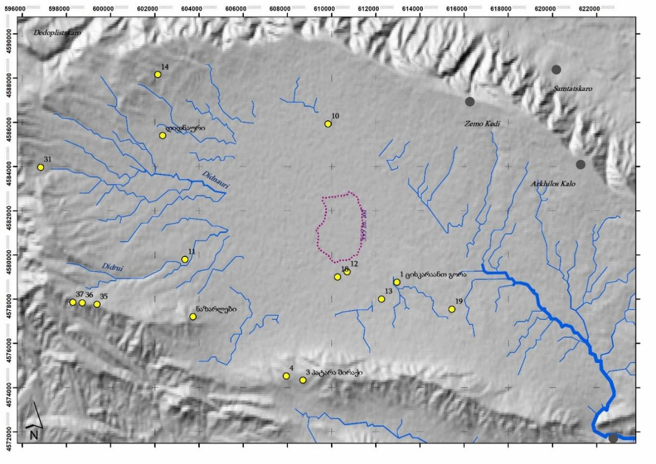
Pic. I. The archaeological objects in the Great Shiraki Valley.
Geographically, this well-defined area has one main entrance from the western side, which passes the valley and is known by the toponym "Long door"1. In the 10th-9th centuries BC it was protected by the strong fortress built on the large stone blocks, with the five-meter-wide dike and the gate fortified with the quadrangular massive towers [Furtwängler, Knauss, Motzenbäkcker, 1998: 309-364].
During the previous years, more than 40 well-planned small, bipartite settlements (with the citadel on the mountain crest and lower residential areas on the mountain slopes separately surrounded by the strong walls and defensive ditches) were found in this sharply demarcated section of Iori Plateau, on the mountains and hills surrounding the valleys.
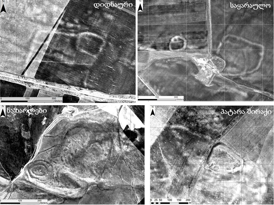
II - The small habitations and Didnauri settlement located in the Great Shiraki Valley.
All these settlements fall within the framework of one culture and date back to the end of the 2nd millennium and the beginning of the 1st millennium. Their burial grounds are also known [Maisuradze, 1988: 61-62; Asatiani, Maisuradze, 2001: 37-65].
In 2014 in the central part of these settlements, namely, in the valley, the small archaeological excavations and decipherment of the satellite images revealed the remains of the grand, apparently central city covering the area of about 15 hectares. This settlement entered the scientific literature under the name "Didnauri".
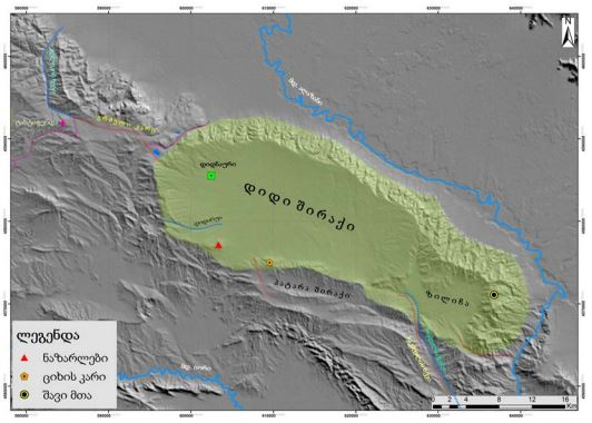
III – The Great Shiraki Valley with the indication to "Didnauri" settlement.
The citadel covers 400x400 meters of these 15 hectares. It is surrounded by the complex 1.5 km long dike, whose width is 7m and height is 15m in accordance to the experts’ calculation. The dike has the pre-Asian-like construction.
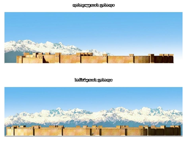
IV. The reconstruction of the dike of “Didnauri” settlement.
As a result of the archaeological research, one of the entrance gates of the city was discovered in the central part of the southern dike.
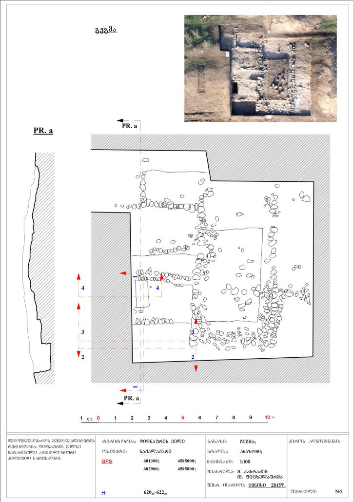
V – The plan of the gate located in the south of the settlement.
It is very essential to find the altar table made of clay in the depth of the southern dike, in the west of the gate. It dates back to the end of the 2nd millennium BC (in accordance to the clay vessels and inscriptions found in the same place).
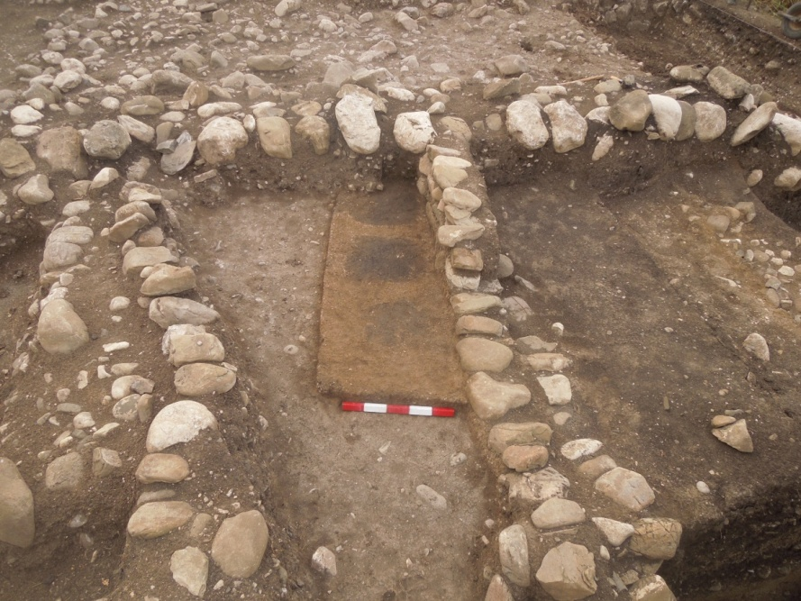
VI – The altar table found at the southern gate.
The intelligence work pointed to the existence of the large reservoir and secret tunnel for supplying the city with water.
There are two large quadrangular sections separated by the strong wall on the territory of the citadel. They apparently required a special protection. The citadel is surrounded by the 15 meters wide defensive moat, while its northern part is surrounded by another wide dike.
As a result of the excavation works on the central part of the western citadel of the settlement, the street paved with the fine stone gravel mass was revealed, adjacent to which the foundations of the cobblestone building were observed.
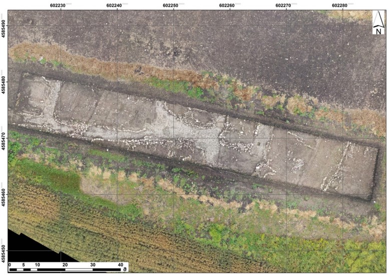
VII – “Didnauri” settlement. The paved street and traces of the foundations of the building.
The sewerage network found under the paved street indicated that the hydroxyl was still quite watery during this period.2 It must be noted that the bronze model of the horse-drawn war chariot was found on one of the chapels of this settlement system, while in the tombs excavated in the burial ground, all men were equipped with the bronze weapons - swords, baselards, spears and axes. This fact indicates to the great fighting potential of the community living here.
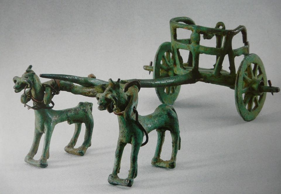
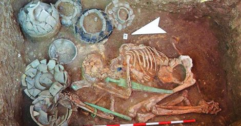
VIII - The model of the bronze chariot and the warrior's tomb.
It should also be noted that on Iori Plateau, far away from the settlements, colossal quantities of the bronze and iron military weapons and agricultural tools were found in two large centers of the religious life of the 10th-9th centuries BC. This fact determines a unique place of this region and its culture in the entire Near East from the point of view of paleometallurgy [Pitskhelauri, 2011: 106-122]
As a rule, clay vessels baked in a light chestnut color were very rare and were not typical for the monuments of Ior-Alazani basin at the second stage of the Late Bronze Age during which "Didnauri" settlement and burial ground existed. However, similar clay vessels should be considered as one of the characteristics of the settlement and burial ground of “Didnauri”. Their forms are typical local forms and do not allow us to attribute them to imported goods. Moreover, encaustic chestnut vessels dipped in a straw-colored paint that are completely uncharacteristic of pottery products of the Caucasus of that time have been frequently observed only on Didnauri monuments - the settlement and burial ground. This technique of decorating clay vessels is not uncommon for the contemporary monuments of West Asia. This fact gives us the opportunity to assume that this South Caucasian technique of decorating clay vessels was borrowed from the West Asian monuments, specifically from the Hittite pottery.
It is possible that the similar connections are indicated by the innovations presented in the forms of clay vessels. In particular, on the settlement of Didnauri, Hereti Plateau, as well as on one of the central settlements of Nazarlebi, we often come across round-shaped, narrowed at tops and erect ears modelled on a shoulder of a clay vessel having typical local forms of the 13th century BC. The similarly shaped ears characterize the Hittite goods. It should be assumed that Caucasian craftsmen were well acquainted with the Hittite pottery and details characterizing it, for instance, covering vessels with engobe, erect ears, decorating clay vessels with animal sculptures, etc. This had earned Caucasian entrepreneurs’ approval, which was later transferred to local goods.
At the same time, we have many fragments of pottery products from the area of the settlement, which apparently are not local in accordance to their quality, processing and appearance.
Possibly, the connection with the Hittite potters is also indicated by the fact that at that time, sculpting of animal statues on a shoulder of a clay vessel became a characteristic feature of ceramic products on Hereti area. In case of the Hittites, the same was one of the most characteristic features of decoration of clay vessels that might also have a ritual significance.
All these seem to confirm the unification of the community living here in one socio-economic and political system, which bears all the signs of a small state formation.
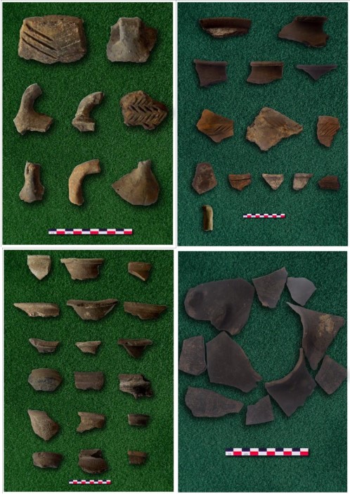
IX – The ceramic goods found on Didnauri burial ground and settlement.
This assumption is supported by the large settlements of the 10th-9th centuries BC with the regular planning and powerful defensive buildings concentrated on Mount Gareji in the western part of Iori Plateau. This fact should indicate to the existence of the small state system.
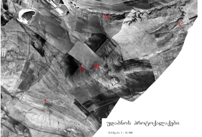
X – The proto-cities of the desert.
As it is known, throughout the Near East, the small states massively appeared during the 10th -9th centuries BC - following the "dark period" of the 12th-11th centuries BC. After the mentioned discoveries on Iori Plateau, it is permissible to consider the South Caucasus as an organic part of the ancient East due to the existence of the seemingly similar socio-economic and political processes.
Conclusions and research questions
According to the specialists’ observation, "Didnauri" settlement was destroyed by the powerful earthquake in the 9th century BC. This fact makes the local archaeological works particularly promising.
The programmatic research of these findings in Eastern Georgia may become a basis for a new understanding of the fundamental problem of the past on the scale of the South Caucasus and possibly, of the entire Near East.
Despite the abundance of the future research issues, the available data give us the reason to assume that the society living on Iori Plateau in the second half of the 2nd millennium BC had the marked signs of the early state formation. Its economic and social development was greatly facilitated by the completely different natural environment (in contrast to today’s one). All aspects of its socio-economic and political life should be discussed only in a complex manner en rapport with the historical natural environment.
The territory of Ior-Alazni is historical Hereti, today's Kakheti. The research of its ancient past has an extremely large national impact. This is caused by a number of unsolved problems in this part of Georgia. These problems are directly related to the historical borders of our country and the issue of the ethno-cultural affiliation of the Kakhetians - the representatives of the community living in this part of our country.
[1]The modern area of “Long door” is from village Gamarjveba to the entrance of Dedoplistskaro.
[2]In 2018-2019, with the financial support of Shota Rustaveli Foundation, Research Center for Cultural Heritage and Environment of Ilia State University carried out the hydrographic network modeling and field geomorphological studies of the Shiraki Valley. The multifaceted material was collected, which lays the foundation for further larger-scale researches that in turn require significant laboratory and analytical works in terms of the analysis of the stratigraphic cores and archaeological material.
References
| Asatiani N., Maisuradze B. 2001 |
The hill-tombs of Dedoplistskaro district. Archaeological Collection III, XXII – XXVI. |
| Pistkhelauri K. 2011 |
The morphology of Nazrlebi burial ground. Khornabuji I. |
| A. Furtwängler., F. Knauss 1997-1998 |
Archäologische Expedition in Kachetien. |
| Motzenbäkcker I. 1998 |
Ausgrabungen in Širaki. Eurasia Antigua. Band 4. |
| Маисурадзе В. 1988 |
Ширакскаия архелологическая експедиция. Полевые археологические иследования. |


